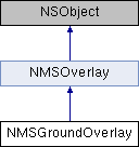
An image overlay on the Earth's surface. More...
#import <NMSGroundOverlay.h>

Class Methods | |
| (instancetype) | + groundOverlayWithBounds:image: |
Convenience constructor for NMSGroundOverlay for a particular bounds and image. More... | |
Properties | |
| NMSCoordinateBounds * | bounds |
| The 2D bounds on the Earth in which image is drawn. More... | |
| UIImage * | image |
| Image to render within bounds on the Earth. More... | |
| CLLocationDirection | bearing |
| Bearing of this ground overlay, in degrees. More... | |
| CGPoint | anchor |
The anchor specifies where this NMSGroundOverlay is anchored to the Earth in relation to bounds. More... | |
| CGFloat | opacity |
| Sets the opacity of the ground overlay, between 0 (completely transparent) and 1 (default) inclusive. More... | |
 Properties inherited from NMSOverlay Properties inherited from NMSOverlay | |
| NSString * | title |
| Title, a short description of the overlay. More... | |
| NSUInteger | zIndex |
| Higher zIndex value overlays will be drawn on top of lower zIndex value tile layers and overlays. More... | |
| NMSMapView * | map |
| The map this overlay is on. More... | |
Detailed Description
An image overlay on the Earth's surface.
Definition at line 13 of file NMSGroundOverlay.h.
Method Documentation
◆ groundOverlayWithBounds:image:()
| + (instancetype) groundOverlayWithBounds: | (NMSCoordinateBounds *) | bounds | |
| image: | (UIImage *) | image | |
Convenience constructor for NMSGroundOverlay for a particular bounds and image.
- Parameters
-
bounds The 2D bounds on the Earth in which image is drawn. image Image to render within bounds on the Earth.
- Returns
- the
NMSGroundOverlayobject
Property Documentation
◆ anchor
|
readwritenonatomicassign |
The anchor specifies where this NMSGroundOverlay is anchored to the Earth in relation to bounds.
Definition at line 33 of file NMSGroundOverlay.h.
◆ bearing
|
readwritenonatomicassign |
Bearing of this ground overlay, in degrees.
Definition at line 30 of file NMSGroundOverlay.h.
◆ bounds
|
readwritenonatomiccopy |
The 2D bounds on the Earth in which image is drawn.
Definition at line 24 of file NMSGroundOverlay.h.
◆ image
|
readwritenonatomicretain |
Image to render within bounds on the Earth.
Definition at line 27 of file NMSGroundOverlay.h.
◆ opacity
|
readwritenonatomicassign |
Sets the opacity of the ground overlay, between 0 (completely transparent) and 1 (default) inclusive.
Definition at line 36 of file NMSGroundOverlay.h.
The documentation for this class was generated from the following file:
- /Users/jenkins/workspace/mobilesdk-ios/iOS/Deployment/NavionicsMobileSDK.framework/Headers/NMSGroundOverlay.h